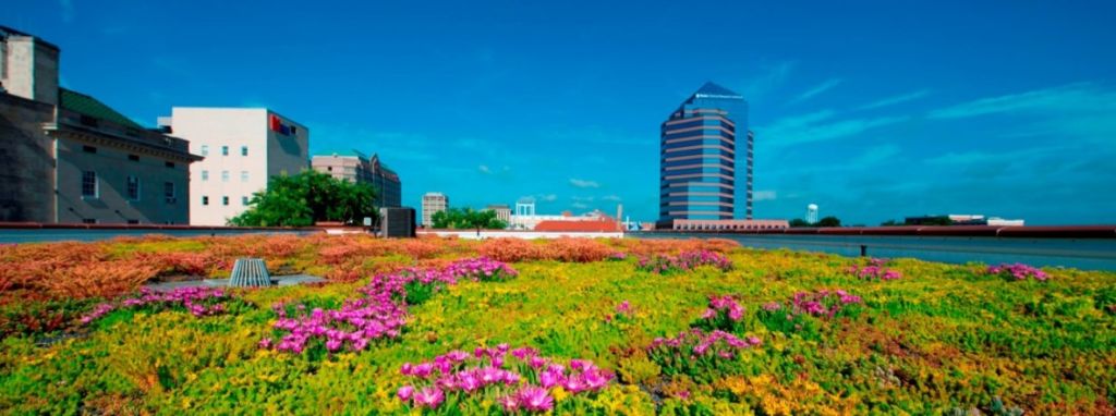
New green roof on Xero Flor Building in downtown Durham, NC.
The Setting
Ellerbe Creek flows out of the heart of Durham, North Carolina through the community on its 14 mile path to Falls Lake Reservoir, a drinking water source for more than half a million people. It offers a refuge for people and nature from the stresses of city life across its compact 37 square mile watershed. The entire creek has been designated as impaired since 1998 for ecological/biological integrity. Falls Lake Reservoir has similarly been identified as an impaired water body due to excessive levels of nitrates and phosphates associated with poorly managed stormwater and failing waste water systems. In 2012, the state of North Carolina approved a plan that requires significant reductions in the current levels of phosphorus (77%) and nitrogen (40%) polluting Falls Lake. Given the disproportionate impact the creek has on these nutrient loads, efforts to restore Ellerbe Creek and its watershed have gained new urgency among conservation groups and local officials in recent years.
Planning for Green Infrastructure in an Urban Watershed
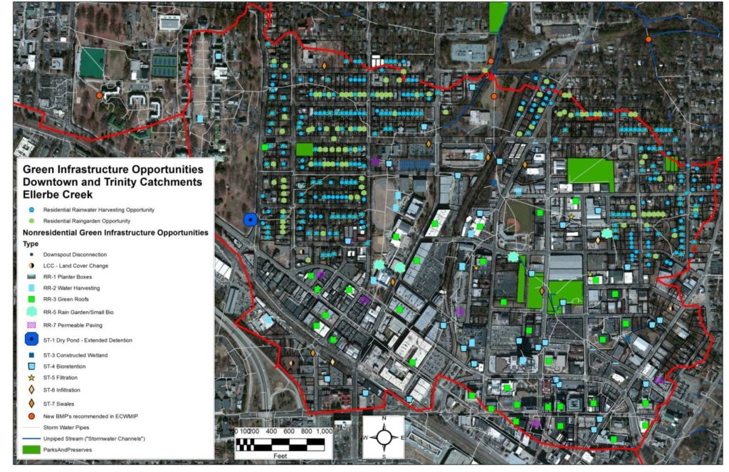
Map of potential sites for green infrastructure projects in the Ellerbe Creek watershed. Source: ECWA
In 2012, ECWA received a $60,000 EPA Urban Waters Small Grant to demonstrate that integrating green infrastructure into the urban landscape can begin to restore a hydrologic balance within Ellerbe Creek. The project has helped quantify the extent to which green infrastructure can reduce excessive amounts of water and remove pollutants, while helping the City of Durham comply with regulations to clean up Falls Lake Reservoir.
The Ellerbe Creek Green Infrastructure Partnership was formed in 2011 by ECWA, the City of Durham, American Rivers, Downtown Durham Inc., North Carolina Cooperative Extension and the Triangle J Council of Governments. A 467-acre drainage area within the watershed was selected to study because it contains a good mix of both residential and commercial land uses, has a high percentage of impervious area (43% impervious), has significant traditional stormwater infrastructure and is the headwaters of the creek. These factors combine to create an unusually high volume of polluted stormwater runoff and ability to measure impact.
The project team conducted a detailed analysis of the green infrastructure opportunities available in residential areas, street right-of-ways and large rooftops and paved lots. It included a Geographic Information Systems (GIS) analysis, field verification and additional analysis, and detailed modeling using the current regulatory modeling tool developed by the State of North Carolina (i.e. Jordan and Falls Lake Stormwater Nutrient Load Assessment Tool) to estimate the pollution reductions that can be achieved through green infrastructure practices.
Results
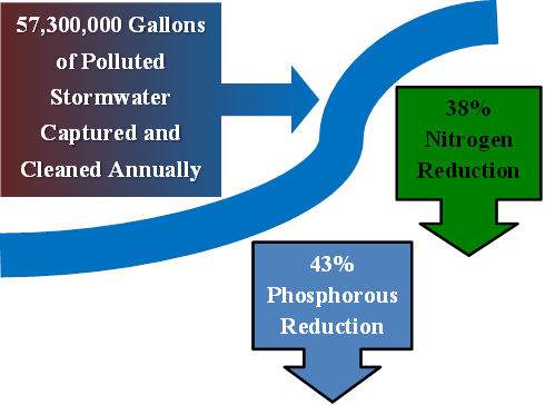
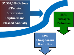
The research and analysis clearly shows that the implementation of many dispersed green infrastructure practices would result in significant pollution reductions.
Lessons Learned
- Green Infrastructure can be part of the solution to restoring an urban creek back to health.
- Integrating green infrastructure into the urban landscape at the catchment scale is a macro-level shirt in landscape management and requires creative problem solving, flexibility, and a vision for resolving stormwater problems comprehensively.
- Green infrastructure can meet the demands of different interests by providing multiple benefits: reduced nutrient pollution, reduced stormwater volume, improved aesthetics, resilience to climate change, increased habitat, reduced heat island, health benefits, etc.
- Comprehensive projects like this need a diverse partnership to succeed.