With issues like vacant lots and urban flooding, the Patapsco Watershed/Baltimore Region Urban Waters Federal Partnership is working with a variety of stakeholders to create solutions through actionable science—or “science you can use”—in the Baltimore region watersheds. Significant strides in greening vacant lots have brought more opportunities and resources to the community; and by prioritizing cross-discipline and cross-jurisdictional partnerships, the Baltimore Actionable Science Flood Team is moving forward work on building community resilience to future flood impacts in the region.
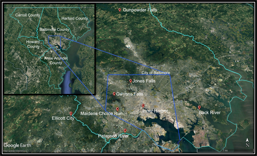
The Baltimore Region Urban Waters Federal Partnership includes the Back River, Gunpowder Falls, and Patapsco River Watersheds and the five counties surrounding the city.
Baltimore Region Watersheds
Watersheds in the Baltimore region include (1) the Back River, covering east Baltimore and adjacent areas of Baltimore County, (2) Gunpowder Falls, a major source of water for the Baltimore region water supply reservoir system, and (3) the Patapsco River that forms the border between Howard and Baltimore Counties. The Patapsco River flows into southwest Baltimore where it shortly becomes a tidal river defining the Baltimore Inner Harbor region, a major inlet to Chesapeake Bay. Gwynns Falls and Jones Falls are major tributaries that discharge into the tidal Patapsco.
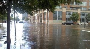
The name Patapsco originates from the Algonquian word pota-psk-ut, meaning backwater or tide covered with froth. Historically, the watershed was used by indigenous tribes for at least 12,000 years. Today, the Native American population is primarily represented by the Lumbee, Piscataway, and Cherokee nations. Black residents make up the largest population of Baltimore City in the eastern portion of the Patapsco Watershed, which is highly developed and subject to water and air quality issues from trash build up and urban run-off, including pollutants contributed from vacant lots. Floods—from coastal storms, riverine flash flooding, and urban stormwater flooding—are also concerns within the Baltimore region watersheds.

Flooding in the Baltimore region is an imminent concern for residents. Photos: US Geological Survey
Baltimore Urban Waters Federal Partnership
The Urban Waters Federal Partnership (UWFP) program was initiated in 2011 with the intention to reconnect urban communities, particularly historically marginalized communities, with their waterways by improving coordination among agencies and supporting community-led revitalization efforts. One of the first UWFP locations, the Patapsco Watershed/Baltimore Region UWFP (or Partnership) is led by the USDA Forest Service. The Patapsco River Watershed was the original footprint of the Partnership; this footprint was expanded to include other important watersheds in the Baltimore region. Today, Ambassadors for the Partnership are housed at the University of Maryland Sea Grant Extension, and the Partnership includes Baltimore City, Baltimore, Howard, Anne Arundel, Carroll, and Harford Counties, and up to 60 municipal, nonprofit and community organizations.
To address the issue of widespread vacant lots in Baltimore City, the Partnership published the Green Pattern Book, a major accomplishment that catalyzed additional projects like the Green Book Registry. More recently—and related to this work—the USDA Forest Service supported the development of Green Resources and Outreach for Watersheds (GROW) Centers in the Baltimore region. These are resource hubs that link residents to plants, supplies, and expertise for greening projects. They also provide free and low-cost trees, mulch, plants and other materials as well as workshops on community greening, vacant lot revitalization, rain gardens and rain barrels, environmental justice, and composting.
Because coastal, riverine, and urban flooding are also major concerns in the Patapsco Watershed, the Partnership takes an actionable science approach to finding solutions. The Baltimore Actionable Science Flood Team was developed in 2018 to promote interdisciplinary and interjurisdictional collaboration on flooding issues.
Actionable Science Flood Team
“There is a philosophy behind this. We want to provide scientific information that people can use.” ~Robert Shedlock, USGS, Co-Chair of Urban Waters Actionable Science Flood Team
On July 31, 2020, the Partnership hosted the Baltimore Urban Waters Partnership Flood Science and Policy Workshop which convened over 80 stakeholders from local nonprofit organizations, academia, and federal, state, and local governments to identify gaps between flood science and regulatory frameworks. The workshop produced recommendations to guide the Partnership’s efforts to address flooding, especially related to social vulnerability and community resilience. The complete summary from the workshop can be found in the Baltimore Urban Waters Flood Science and Policy Workshop Action Report. While the workshop was focused on the Baltimore region, the model used and the lessons learned are applicable to a broader audience.
Overall, the workshop participants identified gaps in understanding the imminent flood risks and greening solutions, particularly for urban flooding. To fill these gaps, the workgroup recommended that scientists, regulators, and policymakers work together to understand risks and create strategies using new tools for tracking and assessing urban flooding and targeting green infrastructure solutions. As many disproportionately impacted communities of color bear the brunt of flooding impacts, the group also identified the need to routinely include social vulnerability in risk assessment and planning. To ensure social and environmental justice, the group recommended forging new cross-discipline partnerships among social scientists, environmental scientists, and policymakers.
Moving forward with the Actionable Science Flood Team priorities, a case study workshop was held in the Maidens Choice Run Watershed—a Maryland Department of Environment Advancing Stormwater Resiliency in Maryland (A-StoRM) pilot watershed—to explore collaborative data gathering, policy development, and management of resources. The participants of the workshop placed a strong emphasis on sustaining safe communities that use a whole watershed approach to resilience that spans across jurisdictions.
Healthier, Safer Baltimore
From greening vacant lots to prioritizing areas for green infrastructure implementation, actionable science is creating a healthier, safer environment for the communities in the Baltimore region. Continuing to forge new partnerships between social, environmental, and political scientists is a priority for the Partnership. Taking a whole watershed approach, engaging the community, and using social vulnerability measures, the work of the Actionable Science Flood Team is elevating the impacts of urban flooding in the Patapsco and other Baltimore region watersheds as well as how to address those impacts in a more holistic, equitable way.
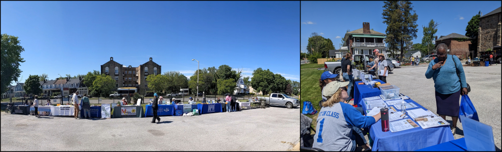
Baltimore residents find information and resources at a GROW Center pop-up. Photos: Claire Cambardella
Resources from the Patapsco Watershed / Baltimore Region Urban Waters Federal Partnership
- Baltimore Urban Waters Flood Science and Policy Workshop Action Report
- Green Resources and Outreach for Watersheds (GROW) Centers
- Video: Salvaging Baltimore with the USDA Forest Service
- Project VITAL
- Stillmeadow PeacePark: Experimental Rehabilitation of an Urban Forest
- Baltimore Urban Waters Partnership 2015 Activity Report
- UWLN impact story: Addressing Baltimore’s Vacant Land Problem