San Juan Bay Estuary
The only tropical estuary within the National Estuary Program (NEP), the San Juan Bay has been recognized as nationally important by the EPA since 1992. Connecting eight municipalities in the most populated urban area of Puerto Rico, the estuary is home to hundreds of thousands of people as well as 500 species of birds, mammals, amphibians, and fish. With shifts in land use from agricultural to urban development, about 70% of the San Juan Bay Estuary Watershed is paved, and forest cover is highly fragmented. The remaining crucial habitats—dunes, mangrove forests, and moist coastal forests—are not only important to the survival of animal and fish species but also provide the first line of defense against tropical storms.
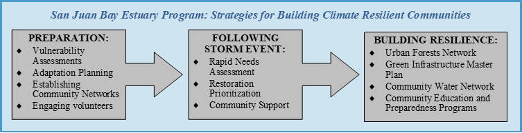
In 2010, the Puerto Rico Climate Change Council convened experts to assess the threats posed by urban development and a changing climate to water quality and coastal habitats and published a State of the Climate Report in 2015. In response to this work, the San Juan Bay Estuary Program (Estuario)—one of the first NEP organizations to use EPA’s Climate Ready Estuaries resources—developed a climate change vulnerability assessment in 2013 and a Climate Change Adaptation Plan in 2015. Estuario found that there was a high probability of risks from increased surface water runoff, more intense precipitation, and failing septic systems. The organization also created adaptation plans that included strategies like infrastructure maintenance, public education, and green infrastructure implementation.
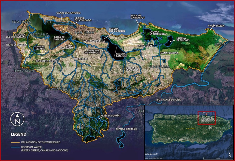
The San Juan Bay Estuary Watershed comprises eight municipalities in northeast Puerto Rico. Nearly 70% of the watershed has undergone urban development. Image modified from Estuario
San Juan Bay Estuary Program: #EstuarioRevive
When Hurricane Maria struck in September 2017, septic and power systems in the San Juan Bay Estuary failed and crucial habitats were destroyed as had been predicted by the vulnerability assessment conducted four years earlier. Although Estuario was prepared to respond, guided by the adaptation plans established in 2015, aging infrastructure, continued development in the watershed, and intense hurricane forces multiplied the impacts of flooding and water pollution. In the aftermath of the storm, it was very clear to Estuario leaders that aggressive actions needed to be taken to increase both the ecological and economic resiliency of the watershed. Estuario doubled-down on its efforts with #EstuarioRevive, an initiative designed to implement projects to monitor, restore, and increase the resilience efforts of the San Juan Bay Estuary.
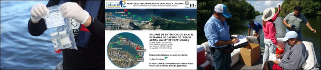
Staff and volunteers collect water quality samples; results are posted on Estuario’s social media outlets. Photos Estuario
Immediately following Hurricane Maria, Estuario was on the ground assessing impacts from the storm and acting to remedy them. The collapse of the sanitary sewer systems posed risks to public health, with high levels of Enterococcus indicating the high probability of harmful pathogens in water. Through funding from the EPA Urban Waters program, Estuario added new locations to the organization’s water quality monitoring program and increased sampling frequency from monthly to weekly. Water quality monitoring activities continue today, the results of which are available to the public through Estuario’s social media platforms. The EPA funding also supported the removal of debris and the initiation of ecological restoration projects.
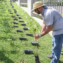
The highest priority restoration projects focused on areas in which ecosystems were destroyed by the hurricane. With the help of volunteers, Estuario planted nearly 3,000 red mangrove seedlings in the Condado Lagoon and the Peninsula La Esperanza in Cantaño. Estuario also developed several green infrastructure programs to further restore the watershed. Other initiatives included establishing an Urban Forest Network to provide tours and lead educational activities for the community within four forests in the watershed and developing a Green Infrastructure Plan to guide reforestation actions in the coming years.
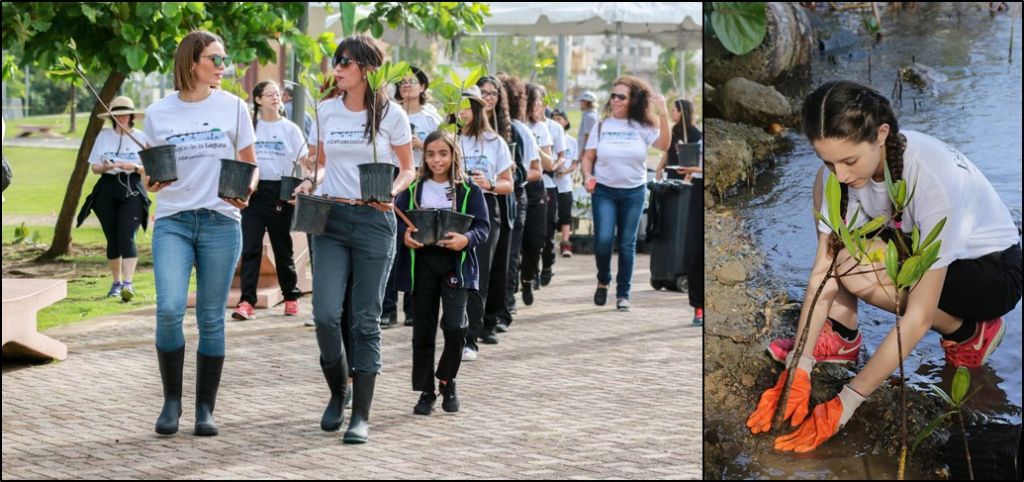
Staff and volunteers plant red mangrove trees in the Condado Lagoon. Photos: Estuario
While monitoring and restoration activities are crucially important, Estuario also recognizes that they are not enough. Emergency preparedness and contingency plans are also a vital part of building resilient communities, as future storms are inevitable and imminent. Using information collected after Hurricane Maria, Estuario developed community-based mitigation strategies and a hurricane preparation guide. In June 2018, Estuario launched a leader training initiative to share their expertise and experience in water resource and emergency management following natural disasters. In addition to sharing information, the program supports disadvantaged neighborhoods by addressing their immediate needs and collecting information on individual community strengths and weaknesses. Through outreach and education, Estuario is empowering communities to adopt programs like #EstuarioRevive, with the intention of establishing climate resilience island-wide.
Preparedness, Action, and Resiliency
In highly developed coastal areas like the San Juan Bay Estuary, the first step to creating resilient communities is conducting vulnerability assessments and drafting adaptation plans that are informed by the anticipated impacts of new patterns of precipitation and coastal storms. Having a plan in place was helpful for Estuario; however, impacts from Hurricane Maria illustrated that Puerto Rico’s vulnerability is heightened by continued development without consideration of more intense storm events and the lack of critical infrastructure updates. After the hurricane, Estuario began the #EstuarioRevive initiative to take more aggressive actions to restore and protect the San Juan Bay Estuary. The assessment, restoration, and preparedness programs of Estuario are not only advancing resiliency in the San Juan Bay Estuary but also encouraging climate adaptation island-wide.
Resources and Further Information:
- EPA Climate Ready Esuaries Program: Being Prepared for Climate Change: A Workbook for Developing Risk-Based Adaptation Plans
- NACLA Report on the Americas: After Maria, Resilience in Puerto Rico
- Puerto Rico Climate Change Council: Puerto Rico Coastal Vulnerability Viewer
- San Juan Bay Estuary Program: Vulnerability Assessment and Adaptation Measures
- San Juan Bay Estuary Program: #EstuarioRevive Video
Mangrove Forests: Natural resources that protect against environmental impacts
Mangrove forests are unique environments that bridge the gap between terrestrial and aquatic habitats in subtropical and tropical coastal systems. Intertwining, submerged root systems provide:
- stabilization to coastlines by decreasing wave energy by up to 75%,
- crucial habitats to aquatic organisms, providing protection and a source of food to about 80% of fish that live on corals, and
- protection from water contamination because the roots act as natural traps to retain sediment and immobilize contaminants.
In the San Juan Bay Estuary Watershed, urban development has decreased mangrove forest cover by 28%-67% percent between 1936-1995 (See a 2014 USDA report: San Juan Bay Estuary Watershed Urban Forest Inventory for more information). Today, the largest mangrove forests of Puerto Rico exist in the San Juan Bay Estuary as part of the Piñones State Forest Nature Reserve. These remaining forests are vital to the health of the estuary. Because the forests are vulnerable to further changes in climate and large storm events, the San Juan Bay Estuary Program is working to restore green spaces while educating communities about the importance of this unique natural resource.